 It was an interesting trip, in all, providing a cascade of often starkly diverse images. How varied a range? On the natural grandeur list, I would add spectacular sunsets, wildernesses of soaring, broken redrock, and broad vistas of pristine desert.
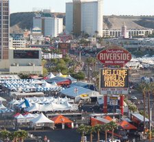
And at the opposite end of the spectrum, I might begin with the sights that greeted me when I crossed the Colorado early in the trip, and threaded my way through the 27th Annual Laughlin River Run, a meet that draws over 40,000 leather-clad, mostly aging bikers to what Motorcycle-usa.com calls, “one of the more popular events on the West Coast rally scene, packing bikini contests, custom bike shows, demo rides, poker runs, freak shows and tattoo contests into four-days of 24/7 fun.” I can attest to the fact that it also packs in what is presumably one of the largest assemblages of multi-story, inflatable Jim Beam bottle and Budweiser can replicas to be found anywhere in one place.
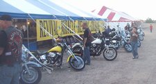 Other memorable images from Laughlin include an elderly man weaving his way through the throng of bikers while carrying a ten foot long cross on his shoulder, although the road to whatever personal Gethsemane he was headed towards was eased by the wheel he had attached to the end of the cross. Presumably, his message had something to do with the old fashioned tent revival that was also in progress, just across the bridge over in BullheadCity. Indeed, it seemed for days on end no matter where I drove as if the Colorado was gathering not all the waters, but all of the bikers of the entire watershed of the West, to the Laughlin/Bullhead City area.
 Heading out of town, I was reminded that this is also gun country, and no one, it seems, wants to miss a good target when they find one. Some mornings, I guess, it doesn’t pay to even leave your garage.
Sadly, that can be true for the rider as well as the vehicle. Not far past this porous monument to the glories of personal artillery ownership, the gravel road I was on took a sharp rise, and then entered a long series of abrupt drops, curves and rises. Just below the first rise I found this creative and durable memorial to Thumper, a biker who apparently never made it home again.
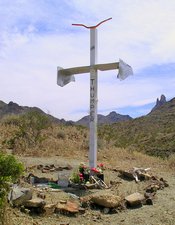 What you see is a remembrance cross of steel, with a spoiler for a crosspiece and a set of motorcycle handlebars as its crown of thorns. In front of it lies an 18” x 24” poured in place concrete pad, in which those that had presumably attended the al fresco dedication had scratched their names as the material hardened. The largest one simply read “Grandma.” Continuing the overall theme of the memorial, a crushed Bud can, and a steel pocket knife, it’s largest blade half open, were also embedded in the concrete.
Around the cross are strewn the flowers you can see, as well as numerous Jaegermeister miniatures, Budweiser cans, hundreds of empty Smith & Wesson 45 caliber shell casings, and a pile of cow bones. Written on the cross itself were many remembrance messages, including:
“You said” you were coming back; I’m still waiting
Two people, one heart
By your side
You just keep riding, Uncle Thumper. I’ll see you again
You dirty bastard, you screwed my wife and brother
Never met you, but heard great things. UR a legend
Soul mate
My bike was faster
And somewhat ironically, in light of the probable trajectory of the final moments of Thumper’s last ride:
Fly high!
I spent awhile on the Internet later on trying to find out anything at all about Thumper and how he met his untimely end. Presumably he knew the road well enough – it wasn’t far from town. Did a car top the rise just ahead of him and wipe him out? Was it suicide by spin-out, or perhaps just one too many Buds? Not a word, or at least a nickname, made it onto the Internet to tell the virtual tale, but Thumper’s physical memorial looks like it will stand there for quite a while to come.
 I encountered a memorial of a different kind when I drove for a while on one of those vestiges of the Route 66 of mid-20th century fame that still survives, and that you are likely to stumble on from time to time if you do a lot of driving west of the Mississippi. No buried Cadillacs on this stretch of the fable Route, nor enormous faux arrows, but I did smile when I saw, for the first time since I was in grade school, a series of Burma Shave signs – and then several more.
Never heard of Burma Shave signs? Once upon a time, you couldn’t drive down a secondary road (of course, there were no “primary roads” then, highways having yet to be invented) without seeing a set of five or six Burma Shave signs stuck in the dirt on the side of the road. The first four or five would tell a quietly humorous mini-story or moral in verse, and the last would simply say “Burma Shave,” the “brushless shaving cream” brand that posted the advertising signs at a time when there was another type of shaving cream from which the Burma Shave product could be distinguished. The verses that I read, sign by nostalgic sign, included the following:
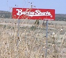 The man who drives/While he’s been drinking/Relies on you/To do his thinking/Burma Shave
If disasters are/Your favorite flower/Keep pump’n up/Your miles per hour/Burma Shave
To go by air/T’would be more fun/If we could put/These signs up there/Burma Shave
Ironically, this collection of replica signs, the only ones now in existence in the wild, can be found in Arizona – one of only three states deemed to be too deserted to merit the attention of Burma Shave ad executives during the ad campaign’s long run from 1925 to 1963.
But happily, my opportunity to accumulate sights on the bizarro list was rather limited, as I spent far more time on Jeep trails than paved roads. Instead, I wound my way on dirt through mountains and canyons, hiked through forests of Ponderosa Pine and Sonoran desert cactus gardens, spotted golden eagles and pinyon jays, photographed snakes and lizards, and experienced much more then I can write about here.

Equally important was what I did not see, because one of the glories of the American west is that if you have nowhere in particular to go and have a mind to, you can head there for days on end without ever seeing a soul, never have to sleep in a campground, and never need to set foot on a trail laid out by someone presuming to know where you want to go – millions of acres of public land are wide open and waiting there to accommodate your solitary wanderlust (although the opinions on that topic of the ranchers that lease most of this land tend to vary from state to state). And while possession of a map and compass and knowing how to use them demonstrates good judgment, merely staying aware of where you’ve been and where you’re headed is usually adequate when you can see for so many miles around.
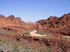 Inevitably, my week of freedom ran its course, and I found myself at the end of a day looking for a suitable last place to camp. I took a Jeep trail that led into a wash, and followed that dry watercourse up hill, taking care to keep my speed up in order to surf through the deep gravel and not get stuck. Soon, I was cutting the corners at full speed while dodging rocks I couldn’t clear when it seemed like I might not make it through a curve without becoming bogged down. The wind was blowing more than half a gale, and my goal was to find a place that not only had a good sunset view, but some shelter from the wind as well in which to lay out my sleeping bag.
At last the wash grew too narrow and sinuous to support further travel safely, so after half an hour of an increasingly wild ride I shot up over the bank and came to rest in a place that was just about right (the return trip the next day was more challenging, because my trip up hill had churned up the gravel in the wash, turning it into a long, dry sluice of mobilized particles).
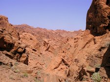 The next day, I followed the wash further up hill on foot, winding through the increasingly high and broken crags of red rock that rose out of the basin between two higher ridge lines of mountains. At mid day, it was time to reverse direction. Rather than return the way I came, I turned to the west, and climbed higher and higher through the vertical towers and broken slabs of red rock that soared above, hoping that when I reached the top an obvious alternate return route to my car would become clear.
When at last I reached the sharp knife edge that marked the boundary between the watershed I had hiked and the one that lay beyond, it became clear that taking the way behind would make more sense than any that lay ahead. As far as the eye could see, a red rock labyrinth extended in every direction, without obvious rhyme, reason, or likely outlet. So I gave it up, and resigned myself to retracing my steps. But in the process of turning back, I found myself looking straight into the eyes of a mountain sheep, not 30 feet away, frozen in place, and waiting to see what I would do next.
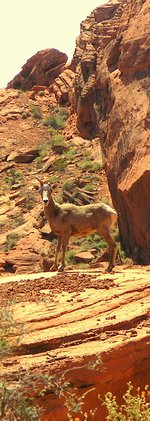 It was a male, perhaps two years old. One of his horns described a third of a full curve, while its mate was only a knob, perhaps broken in an early test of his impetuous youth. To say that I was surprised would be an understatement, as mountain sheep are endangered, rare, extremely skittish, and sharp-eyed beyond human comprehension. Normally, they know where you are when you are far, far away, and take care to maintain that distance. I had never seen one before without the aid of binoculars, and not often then.
Continuing to stare into the ram’s eyes, I slowly eased my camera with one hand to the top of my pocket, turned it on, set the lens to maximum magnification, and then slowly brought it up to my eye. I got one good picture before the ram bolted and disappeared, dropping silently into the void below and out of sight, disappearing in an instand as if he had never been there at all. I stood there for a time after that, alone above the chaotic world of red rock laid out below me, and with nothing but the silent breeze to keep me company above.
That night, I slept at an airport hotel, and the day in my own bed at home. The stars are much fainter to the eye here, and I wonder how long it will be before I see a sight like that again.
For further blog entries in Not Here but There: a Wilderness Journal, click here